
Kanin – Rombon
By:
Access to Starting Point:
- From Kranjska Gora (via Vršič Pass or Predel Pass through Italy):
- Drive through Bovec, bypass the town center, and head toward the nearby gas station.
- Turn left at the station and follow the road to the parking lot at the cable car’s lower station for Kanin.
- Buy a ticket and take the cable car to D Station.
- From Tolmin:
- Drive toward Bovec, take a left just before the town center at the gas station, and follow the road uphill to the cable car parking area.
- Purchase a ticket and ride the cable car to D Station.
Trail Description:
From D Station, head toward the base of the Prevala chairlift, then follow the marked trail on the right toward Prestreljenik and Rombon. The path ascends along the edge of the ski slope, eventually reaching a saddle where the chairlift has an intermediate station.
- Route to Sedlo Prevala:
The trail gradually descends alongside the ski slope, with the option to continue directly on the slope. Pass by some large sinkholes before reaching the steeper and slightly exposed sections of the trail. Using cables for support, descend to Sedlo Prevala, where five trails meet. - Towards Rombon:
From Prevala, follow the trail eastward toward Lope (2406 m). The path alternates between climbs and descents, passing a saddle between Lope and Kotlo (1881 m). It then skirts numerous sinkholes characteristic of the Kanin range.Upon reaching a fork, take the path leading to Rombon and Speleological Bivouac. After a short ascent, you’ll reach a saddle between Črnelska Špica and Vrh Ribežnov. From here, descend slightly to a junction near the bivouac. - Final Ascent to Rombon:
Continue left toward Rombon, bypassing Prišna Glava and a small natural spring (dry during droughts). The trail, marked by remnants of WWI trenches and structures, ascends steadily toward the summit. The last section becomes steeper and slightly exposed, leading to the panoramic summit of Rombon (2208 m).
Notable Features:
- WWI ruins and fortifications
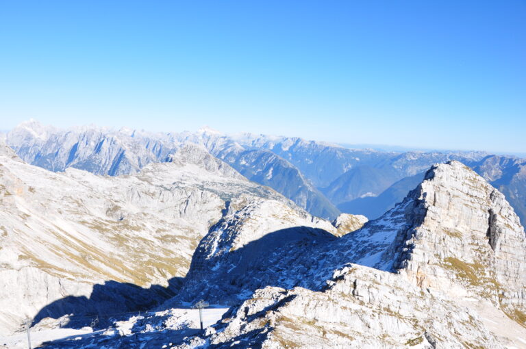
- Stunning views of the Julian Alps
- Unique sinkholes of the Kanin range
Trail Segments:
- D Station to Prevala Saddle: 2:30
- Prevala to Rombon Summit: 2:30
Total Ascent: Approx. 550 m
Pro Tip: Carry a headlamp to explore the WWI bunkers and trenches along the way.
Highlights:
This trail offers an incredible blend of natural beauty and historical significance, with traces of WWI scattered throughout the journey. While the trek is moderately challenging, the stunning views and unique geological features make it an unforgettable experience.
Difficulty: Moderately challenging, marked trail
Starting Point: D Station (2202 m)
Coordinates: 46.3326°N, 13.5384°E
Ending Point: Rombon (2208 m)
Hiking Time: 5 hours
Elevation Gain: 6 m (net)
Elevation Gain - Trail: 550 m
Map: Julian Alps - Western Part, 1:50,000
Recommended Gear: Summer: Standard hiking equipment
Recommended Gear: Winter: Ice axe, crampons