
Experience the Soča Valley
Sports and Outdoor Adventure
Water:
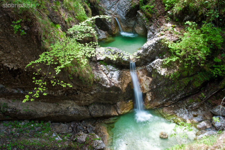
Soteskanje Fratarica
FRATARICA
Podajte se na nepozabno avanturo: Canyoning v kanjonu Fratarice
V slovenskem Triglavskem narodnem parku, v bližini očarljive vasice Log pod Mangartom,
se nahaja kanjon Fratarica – raj za avanturistične navdušence, ki iščejo vznemirljivo
izkušnjo soteskanja. Fratarica, poznana po neokrnjenih slapovih, smaragdnih tolmunih in
bujnem alpskem okolju, ponuja popolno mešanico adrenalina in naravne lepote.
Pregled turneje
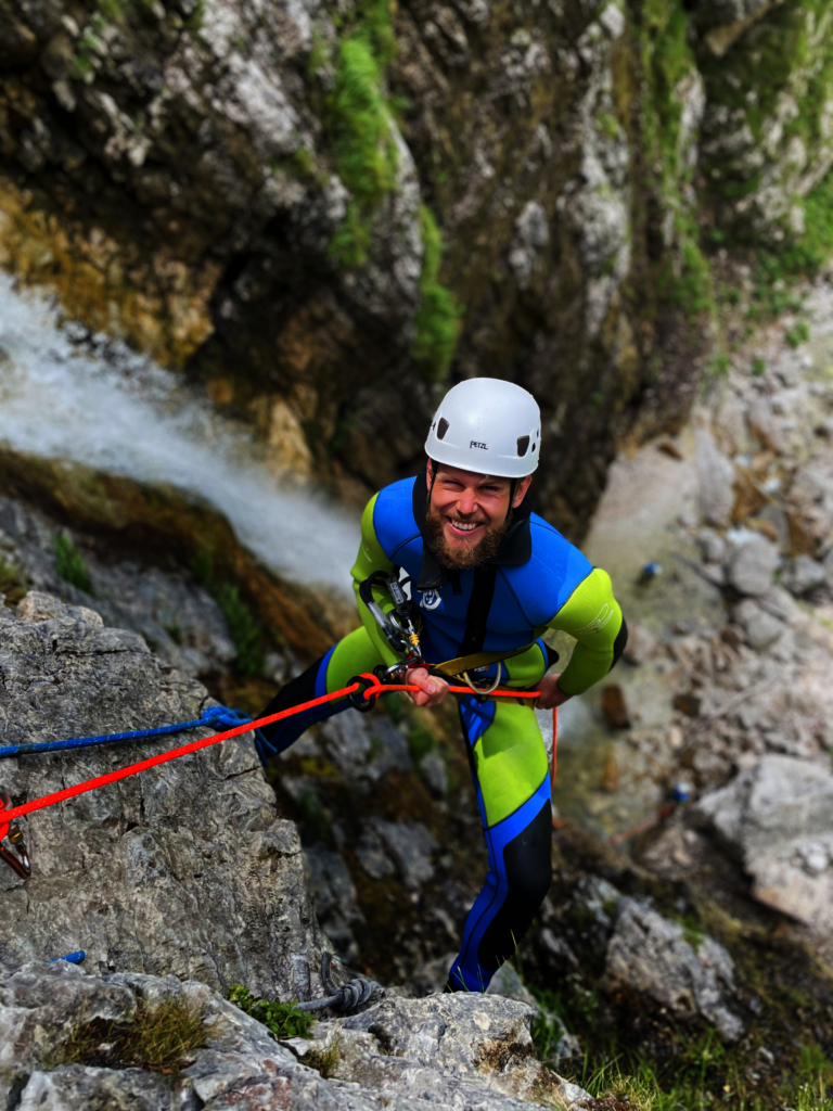
Vaše potovanje se začne v Bovcu, kjer se srečate z našimi prijaznimi in izkušenimi vodniki
v bazi Canyoning Challenge. Po topli dobrodošlici in kratki predstavitvi vas bomo opremili z
vrhunsko opremo za soteskanje, vključno z neoprenskimi neoprenskimi oblekami, čevlji za
soteskanje, pasovi in čeladami. Varnost je naša najpomembnejša prednostna naloga in
naši vodniki bodo poskrbeli, da boste dobro pripravljeni na pustolovščino, ki je pred vami.
Pristop
Kratka vožnja nas pripelje do izhodišča poti pri Logu pod Mangartom. Tu začnemo
30-minutni pohod po slikovitem alpskem terenu, ki vam omogoča, da se vpijete v dih
jemajoče razglede na Julijske Alpe. Ta poživljajoč sprehod služi kot ogrevanje in krepi
pričakovanje vznemirjenja, ki prihaja.
Vstop v kanjon
Ko pridete do vhoda v kanjon, se izvede obsežen varnostni sestanek. Naši vodniki bodo
prikazali bistvene tehnike, kot so pravilna uporaba opreme, metode spuščanja in varna
navigacija skozi značilnosti kanjona. Vsi samozavestni in pripravljeni se začne spust v
Fratarico.
Spust
Kanjon Fratarica predstavlja vrsto naravnih ovir, od katerih vsaka ponuja svojevrstno
vznemirjenje:
Slapovi in spuščanje po vrvi: Doživite vznemirljivo spuščanje ob kaskadnih slapovih.
Vrhunec je veličasten slap Parabola, ki se ponaša s 50-metrskim (164 čevljev) navpičnim
padcem – najvišji spust po slapu v Sloveniji. Pod skrbnim nadzorom naših vodnikov se
boste spuščali po tej impresivni lastnosti, doživetje, ki združuje adrenalin in osupljivo
lepoto.
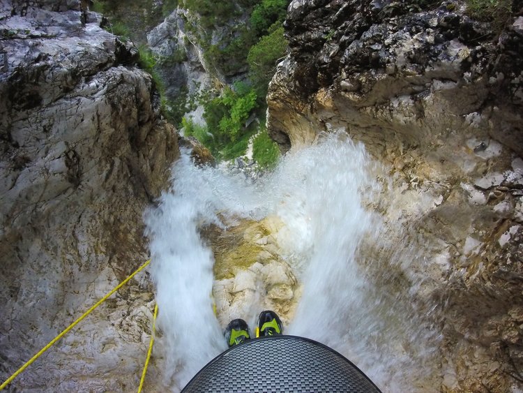
Naravni tobogani: Občutite hitenje, ko drsite navzdol po gladkih kamnitih formacijah, ki jih
je izklesalo tisočletje vodnega toka. Ti naravni tobogani zagotavljajo razburjenje in
osvežujoč potop v kristalno čiste tolmune.
Skoki: tistim, ki iščejo dodatno dozo adrenalina, ponuja Fratarica možnost skokov z višin v
globoke, vabljive tolmune. Čeprav ti skoki niso obvezni, avanturi dodajo vznemirljiv
element.
Zip-line: Pri slapu Katedrala izkusite vznemirljiv 45-stopinjski spust z zip-line, ki vašemu
soteskanju doda edinstven pridih.
Izkušnja
Med približno 2,5-urnim spustom se boste potopili v spokojno lepoto kanjona. Smaragdni
bazeni, izklesane skalne formacije in bujna vegetacija ustvarjajo mirno ozadje, ki popestri
avanturo s trenutki mirnega razmišljanja. Naši vodniki vam bodo s svojim obsežnim
poznavanjem območja delili vpogled v geologijo in ekologijo kanjona ter tako obogatili vašo
izkušnjo.
Zaključek
Po navigiranju skozi izzive kanjona nas kratek 5-minutni sprehod vrne do naših vozil. V
bazi se boste lahko preoblekli v suha oblačila in podoživeli vrhunce dneva s svojimi
sopotniki. Zagotovili vam bomo fotografije, posnete med potovanjem, da boste svoje
nepozabno doživetje lahko delili s prijatelji in družino.
Zakaj izbrati Fratarico?
Kanjon Fratarica je idealen tako za začetnike kot za izkušene ljubitelje soteskanja.
Njegove raznolike funkcije ponujajo celovito izkušnjo soteskanja, od skakanja in drsenja do
skokov in zipline. Lega kanjona v Triglavskem narodnem parku zagotavlja neokrnjeno
naravno lepoto, zato je obvezna destinacija tako za ljubitelje narave kot za pustolovščine.
Kanjon Fratarice vas čaka—potopite se v vznemirjenje soteskanja in sijaj slovenske
alpske divjine.
FRATARICA
Embark on an Unforgettable Adventure: Canyoning in Fratarica Canyon
Nestled within Slovenia’s Triglav National Park, near the quaint village of Log pod
Mangartom, lies Fratarica Canyon—a haven for adventure enthusiasts seeking an
exhilarating canyoning experience. Renowned for its pristine waterfalls, emerald pools, and
lush alpine surroundings, Fratarica offers a perfect blend of adrenaline and natural beauty.
Tour Overview:
Your journey begins in Bovec, where you’ll meet our friendly and experienced guides at the
Canyoning Challenge base. After a warm welcome and a brief introduction, we’ll equip you
with top-quality canyoning gear, including neoprene wetsuits, canyoning shoes, harnesses,
and helmets. Safety is our utmost priority, and our guides will ensure you’re well-prepared
for the adventure ahead.
The Approach:
A short drive transports us to the trailhead near Log pod Mangartom. Here, we commence
a 30-minute hike through picturesque alpine terrain, allowing you to soak in the
breathtaking vistas of the Julian Alps. This invigorating walk serves as a warm-up, building
anticipation for the thrills to come.
Entering the Canyon
Upon reaching the canyon’s entrance, a comprehensive safety briefing is conducted. Our
guides will demonstrate essential techniques, such as proper use of equipment, rappelling
methods, and safe navigation through the canyon’s features. With everyone confident and
ready, the descent into Fratarica begins.
The Descent
Fratarica Canyon presents a series of natural obstacles, each offering a unique thrill:
Waterfalls and Rappels: Experience the exhilaration of descending alongside cascading
waterfalls. The highlight is the majestic Parabola waterfall, boasting a 50-meter (164 feet)
vertical drop—the tallest waterfall descent in Slovenia. Under the careful supervision of our
guides, you’ll rappel down this impressive feature, an experience that combines adrenaline
with awe-inspiring beauty.
EXPLORE SHARE
Natural Slides: Feel the rush as you glide down smooth rock formations sculpted by
millennia of water flow. These natural slides provide both excitement and a refreshing
plunge into crystal-clear pools.
Jumps: For those seeking an extra dose of adrenaline, Fratarica offers opportunities to
leap from heights into deep, inviting pools. While these jumps are optional, they add an
exhilarating element to the adventure.
Zip-line: At the Cathedral waterfall, experience a thrilling 45-degree zip-line descent,
adding a unique twist to your canyoning journey.
The Experience:
Throughout the approximately 2.5-hour descent, you’ll be immersed in the canyon’s serene
beauty. The emerald pools, carved rock formations, and lush vegetation create a tranquil
backdrop, enhancing the adventure with moments of peaceful reflection. Our guides, with
their extensive knowledge of the area, will share insights into the canyon’s geology and
ecology, enriching your experience.
Conclusion
After navigating the canyon’s challenges, a brief 5-minute walk returns us to our vehicles.
Back at the base, you’ll have the opportunity to change into dry clothes and relive the day’s
highlights with your fellow adventurers. We’ll provide photos captured during the tour,
allowing you to share your unforgettable experience with friends and family.
Why Choose Fratarica?
Fratarica Canyon is ideal for both beginners and seasoned canyoning enthusiasts. Its
diverse features offer a comprehensive canyoning experience, from rappelling and sliding
to jumping and zip-lining. The canyon’s location within Triglav National Park ensures
unspoiled natural beauty, making it a must-visit destination for nature lovers and adventure
seekers alike.
Book Your Adventure
Ready to embark on this unforgettable journey? Contact Canyoning Challenge to reserve
your spot. Our experienced guides are dedicated to providing a safe, enjoyable, and
memorable canyoning experience in one of Slovenia’s most stunning natural settings.
Fratarica Canyon awaits—immerse yourself in the thrill of canyoning and the splendor of
Slovenia’s alpine wilderness.
OPIRANO in prilagojeno OD NATURE’S FAGs
Duration
About 4 – 5 hours.
Difficulty
Beginner friendly.
Departures
● 15th of April – 14th of May – Every day at 9.00.
● 15th of May – 14th of September – Every day at 9.00 and 15.00.
● 15th of September – 31st of October – Every day at 9.00.
It is recommended to arrive at our meeting point 10 min early.
Requirements
● Participants must be able to swim.
● Participants with any health issues or recent injuries must consult with
us before attending the canyoning tour.
● The tour is not suitable for pregnant women.
● Weight limit – 115kg.
● A moderate level of physical fitness is required.
● The tour starts with a 25-30 minute uphill hike.
What’s included
● Professional equipment (also special canyoning shoes), thoroughly
washed and disinfected after every use.
● Professional and certified canyoning guide.
● Transfer to the canyon and back to our meeting point.
● FREE photos.
What do i need
A towel, a bathing suit and dry clothes to change after the tour.
Minimum age
10 years for Fratarica
7 years for Sušec
Group size
Mostly 4 to 6 but up to 8 participants in a group.
Our focus on small groups allows us to provide our guests with an enjoyable and
memorable time with us.
Soteskanje sušec
SUŠEC
Doživite popolno avanturo v kanjonu Sušec!
Kanjon Sušec, ki leži le 7 kilometrov od Bovca, je ena najbolj priljubljenih destinacij za
soteskanje v Sloveniji. Njegova dostopnost, slikovita lepota in naravne ovire naredijo ta
kanjon idealen za začetnike, družine in vse, ki želite doživeti zabavno in varno avanturo v
osrčju Triglavskega narodnega parka.
Potek izleta
Vaša pustolovščina se začne v Bovcu, kjer vas pričaka ekipa Canyoning Challenge. Po
toplem sprejemu in kratkem uvodu prejmete vrhunsko opremo: neoprenske obleke, čevlje,
čelado in plezalni pas. Naši vodiči bodo poskrbeli za podrobno varnostno predstavitev in
osnovno usposabljanje, da se boste na poti počutili samozavestno in sproščeno.
Kratek prevoz vas pripelje do vhoda v kanjon Sušec. Po približno 30 minutah hoje skozi
čudovito alpsko pokrajino boste prispeli do začetka kanjona, kjer se začne pravo
vznemirjenje.
Doživetje v kanjonu
Kanjon Sušec je znan po svojih kristalno čistih tolmunih, naravnih toboganih in slikovitih
slapovih, ki skupaj tvorijo naravni vodni park. Na poti boste premagovali različne ovire:
● Skoki v tolmune: Zabavno skakanje v osvežujoče bazene, ki vas bo napolnilo z
adrenalinom.
● Naravni tobogani: Drsenje po gladkih kamnitih toboganih, ki jih je skozi
tisočletja oblikovala voda. Najdaljši tobogan meri kar 12 metrov in zagotavlja
pravi adrenalinski užitek.
● Spusti ob slapovih: Premagovanje slapov z uporabo vrvi, pri čemer je najvišji
slap visok 22 metrov.
Vse ovire so prilagojene različnim stopnjam poguma. Če se želite izogniti skokom ali
drsenju, je vsako oviro mogoče obiti po varni poti. Naši vodiči bodo vedno ob vas, da
zagotovijo varno in zabavno izkušnjo.
Zaključek izleta
Po približno 2,5 urah vznemirljivega soteskanja se odpravimo na kratek pohod nazaj do
vozil. Ob vrnitvi v bazo se lahko preoblečete, osvežite in podoživite najboljše trenutke
dneva. Naši vodiči vam bodo z veseljem predali fotografije in videoposnetke, ki so jih
posneli med vašim spustom.
Zakaj izbrati kanjon Sušec?
Kanjon Sušec je idealna izbira za vse generacije zaradi svoje dostopnosti, raznolikih ovir in
naravne lepote. Začetniki bodo uživali v varnih, a vznemirljivih izzivih, medtem ko bodo
družine cenile prilagodljivost poti in strokovnost naših vodičev.
Pridružite se nam in odkrijte čarobnost kanjona Sušec—nepozabno doživetje v srcu
Slovenije!
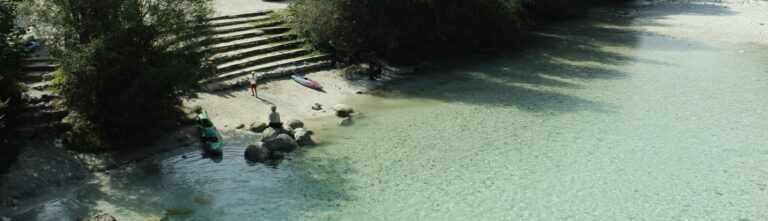
Kajak Šola
Accompanied by an experienced guide, you’ll play in currents and whirlpools, and occasionally find peace in emerald pools. We guarantee that a kayaking adventure on the Soča is worth the effort. If you’re a beginner, we recommend taking at least a two or three-day kayaking course before tackling the rapids.
Once you’ve mastered the basic paddling techniques, you can also embark on more adrenaline-filled and technical rapids with a guide, which will take you past forests and gorges to the stony, sandy beaches of the Soča Valley. Of course, you’ll need to focus on the rapids ahead, which you’ll navigate together with your experienced guide. Along the way, there will also be time to pause, take a deep breath, and admire the beauty of the river.
There are multiple sections on the Soča River, offering endless opportunities for exploration as you improve your skills. Learning how to kayak can sometimes be challenging and a bit uncomfortable at first, but once you get the hang of maneuvering through swift currents and dynamic waters, there’s no better feeling. Navigating obstacles, catching eddies, and even surfing waves can become truly exhilarating. With confidence in yourself and your abilities, everything becomes achievable.

Kayak spust
Then, you’ll begin an exciting trip through different parts of the Soča River, discovering not only its breathtaking beauty but also your own abilities as you navigate the waters. This beginner-friendly section offers stunning spots to pause and soak in the scenery.
Along the way, you’ll have the opportunity to see Slovenia’s biggest waterfall, the majestic Boka, as well as Triglav Mountain, and explore many more of the natural wonders this river has to offer.
The equipment provided for kayaking down the Soča River includes a helmet, paddle, long john wetsuit, neoprene shoes, and an anorak for colder or rainy days.
We recommend bringing a swimsuit, a towel, and sunscreen. If you wear glasses, consider using a strap to secure them. All other equipment is provided.
The tour is family-friendly. Children as young as they can comfortably swim and are taller than 140cm can participate as long as they can swim.
Children up to 14 years old can participate in more demanding activities (Soča rafting, canyoning, kayaking) only when accompanied by parents, guardians, or another adult.
Sella Nevea – Rombon
Access to Starting Point
Option A: Via Kranjska Gora
- Drive through Rateče into Italy.
- Head towards Tarvisio and turn left towards Bovec at the start of the town.
- Continue along the regional road towards the Predel Pass, following signs for Rabeljsko Jezero (Lago del Predil).
- At the junction near the lake, turn right towards Sella Nevea (Nevejski Preval).
- Drive up to the large parking area at the lower cable car station for Rifugio Gilberti.
Option B: Via Bovec
- Drive towards the Predel Pass from Bovec and cross into Italy.
- After descending past Rabeljsko Jezero, take a left turn towards Sella Nevea (Nevejski Preval).
- Follow the ascending road to the parking area near the cable car station for Rifugio Gilberti.
Trail Description
- Initial Ascent
- From the parking area, take the narrow asphalt road near Hotel Nevea.
- Follow signs for Trail 636, which leads left across a meadow onto a marked hiking path.
- Continue through a forest, ascending along an old military mule track.
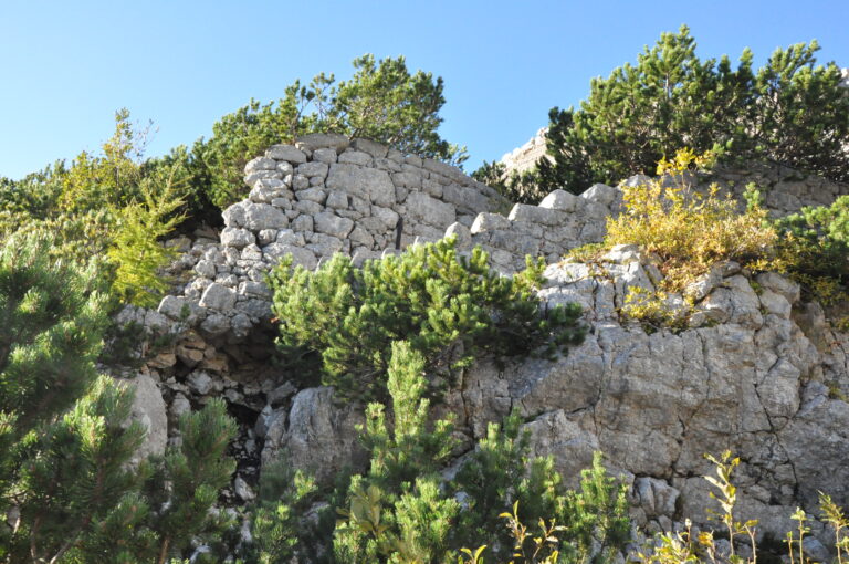
- Kasarna Poviz Ruins
- Higher up, the forest thins out, offering panoramic views.
- The trail leads to the ruins of Kasarna Poviz, a historic site from World War I.
- Path to Prevala Saddle
- At a marked fork, head left towards Prevala Saddle (ignore the right path to Rifugio Gilberti).
- The path levels out and becomes more scenic, eventually leading to another junction.
- Continue right towards Prevala Saddle, ascending steadily across rocky terrain and scree slopes.
- Prevala Saddle (5-way Junction)
- At the saddle, take the left trail marked for Rombon (paths to Bovec and Prestreljenik go straight and right, respectively).
- Traverse Across Lope Slopes
- Follow the undulating trail eastwards, passing scree slopes and sinkholes typical of the Kanin massif.
- Reach a smaller saddle between Lope (2406 m) and Kotl (1881 m).
- Ascent Towards Rombon
- Pass another fork where the trail to Črnelska Špica (2332 m) splits left. Continue right towards Rombon and the Speleological Shelter.
- The trail climbs steeply before descending to a minor saddle between Črnelska Špica and Vrh Ribežnov.
- Final Push to the Summit
- Pass the Speleological Shelter, continuing left towards Rombon.
- The trail ascends steeply past Prišna Glava, with remains from WWI visible along the way.
- Near the summit, the path becomes steeper and slightly exposed, requiring caution.
Key Notes
- Water Sources: A small spring is present along the way but may dry up in summer.
- Historical Interest: The route is dotted with WWI remnants, including bunkers and military paths.
- Winter Conditions: Additional equipment (helmet, ice axe, crampons) is essential due to potential snow and ice.
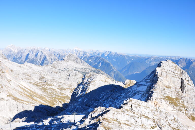
Enjoy the breathtaking views and the historical richness of this moderately challenging trail to Rombon (2208 m)!
Kanin – Rombon
Access to Starting Point:
- From Kranjska Gora (via Vršič Pass or Predel Pass through Italy):
- Drive through Bovec, bypass the town center, and head toward the nearby gas station.
- Turn left at the station and follow the road to the parking lot at the cable car’s lower station for Kanin.
- Buy a ticket and take the cable car to D Station.
- From Tolmin:
- Drive toward Bovec, take a left just before the town center at the gas station, and follow the road uphill to the cable car parking area.
- Purchase a ticket and ride the cable car to D Station.
Trail Description:
From D Station, head toward the base of the Prevala chairlift, then follow the marked trail on the right toward Prestreljenik and Rombon. The path ascends along the edge of the ski slope, eventually reaching a saddle where the chairlift has an intermediate station.
- Route to Sedlo Prevala:
The trail gradually descends alongside the ski slope, with the option to continue directly on the slope. Pass by some large sinkholes before reaching the steeper and slightly exposed sections of the trail. Using cables for support, descend to Sedlo Prevala, where five trails meet. - Towards Rombon:
From Prevala, follow the trail eastward toward Lope (2406 m). The path alternates between climbs and descents, passing a saddle between Lope and Kotlo (1881 m). It then skirts numerous sinkholes characteristic of the Kanin range.Upon reaching a fork, take the path leading to Rombon and Speleological Bivouac. After a short ascent, you’ll reach a saddle between Črnelska Špica and Vrh Ribežnov. From here, descend slightly to a junction near the bivouac. - Final Ascent to Rombon:
Continue left toward Rombon, bypassing Prišna Glava and a small natural spring (dry during droughts). The trail, marked by remnants of WWI trenches and structures, ascends steadily toward the summit. The last section becomes steeper and slightly exposed, leading to the panoramic summit of Rombon (2208 m).
Notable Features:
- WWI ruins and fortifications
- Stunning views of the Julian Alps
- Unique sinkholes of the Kanin range
Trail Segments:
- D Station to Prevala Saddle: 2:30
- Prevala to Rombon Summit: 2:30
Total Ascent: Approx. 550 m
Pro Tip: Carry a headlamp to explore the WWI bunkers and trenches along the way.
Highlights:
This trail offers an incredible blend of natural beauty and historical significance, with traces of WWI scattered throughout the journey. While the trek is moderately challenging, the stunning views and unique geological features make it an unforgettable experience.
Kluže Fort – Rombon
Getting to the Starting Point:
Head out from Bovec in the direction of the Predel border crossing. After a few kilometers, you’ll come across Kluže Fort on your right, where you’ll find a parking lot nearby to leave your vehicle.
Trail Overview:
Start your hike by crossing the road and taking the wide trail directly opposite Kluže Fort. The path begins with a gentle incline and soon leads to a historic military tunnel. Since the tunnel is quite long and dimly lit, carrying a headlamp or flashlight is highly recommended. Once through the tunnel, you’ll come to a junction—follow the left path marked toward Na Robu (elevation 1313 m).
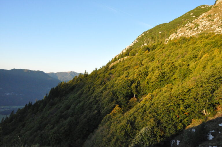
The trail briefly becomes steep before leveling out into a gentle traverse, offering glimpses of Kluže Fort below. About 30 minutes in, the route reaches Fort Hermann, another impressive military structure from the past. From here, take the right-hand path toward Rombon, which climbs steeply through a dense forest. Follow the trail markers, initially pointing toward Na Robu and later transitioning to signs for 1313.
Roughly two hours into the hike, the forest opens up to reveal a stunning viewpoint overlooking the peaks of Jerebica and the Koritnica Valley below. After enjoying the scenery, the trail leads back into the forest and eventually splits again. Take the path marked for Rombon and continue to follow the markings.
The steep climb begins to ease, and you’ll emerge onto open terrain with sweeping views of the Bovec Basin and surrounding mountains. From this point, the trail becomes less distinct as it crosses grassy slopes, but well-placed trail markers help keep you on track. A short stretch through another forested section brings you to a slope covered in dwarf pines.
Here, you’ll join an old military mule track, which winds through increasingly panoramic landscapes and passes by remnants of wartime structures. The trail leads through ruins, with clear markers ensuring you don’t lose your way in the maze of stone walls. After continuing along the mule track, the trail shifts to grassy slopes. These sections, while generally moderate in incline, can be slippery in wet conditions, so caution is advised.
You’ll then ascend a shallow valley that leads to an indistinct saddle where the trail intersects with another path coming from Bovec (Za Vrzelno). At this point, turn right and tackle a short, steep section that requires scrambling up a 5-meter rocky step using natural handholds—take care here, especially on the descent.
The trail then levels out slightly, winding across the final summit slopes. From here, follow the increasingly breathtaking route to the peak of Rombon, where you’ll be rewarded with spectacular views of the Julian Alps.
Zavrzelno – Rombon
Getting to the Starting Point:
From the center of Bovec, follow the road uphill past the church in the direction of Kaninska Vas. Continue straight at the first junction, where the left road leads down to Plužna. Shortly after, you’ll reach another intersection—take the right road signposted for Rombon. Drive until the road crosses a stream; here, you’ll find a small parking area near trail signs and a natural spring.
Trail Description:
Begin your hike at the spring, where the trail markers guide you onto a footpath (not the dirt road). The path initially ascends through sparse woodland before transitioning into a denser forest after about 15 minutes. The moderate climb continues, crossing remnants of old military mule tracks. After roughly 1.5 hours, the forest clears, and the trail emerges onto grassy slopes leading to Planina Goričica, where a hunting cabin is located.
From here, enjoy the views of the peaks to the south of the Bovec Basin. Follow the trail to the right, which leads to a junction after a few minutes. Take the lower (right) path toward Rombon (the left trail leads to Črnelska Špica). This section passes the ruins of an old military hospital; a memorial plaque is located just a few meters off the marked path.
The trail turns left here, crossing a final forested section before opening up to reveal numerous wartime tunnels on your right (a cross can be seen on the opposite side). Continue uphill on the worn mule track, passing a series of war relics. The path eventually levels out, offering your first clear view of Rombon ahead.
Follow the trail straight (a short detour to the right leads to Čukla in 3 minutes). The route climbs gradually before reaching the base of Rombon’s rocky cliffs. Here, the trail veers left and ascends steep scree slopes at the foot of the cliffs. This demanding section eventually turns sharply right into a pronounced gully. Be cautious on this steep terrain to avoid dislodging rocks, which can pose serious danger to hikers below. (In early summer, patches of snow may still linger here.)
Higher up, the trail reaches a ridge where it intersects with the route from Kluže Fort. Turn sharply left and ascend a short but steep rocky step (about 5 m) using natural handholds. This section requires extra caution, especially during descent.
Beyond this point, the trail becomes less steep, winding up the final slopes of Rombon. Follow the increasingly scenic path to the summit, where you’ll be rewarded with panoramic views of the Julian Alps.
Due to the numerous wartime tunnels along the route, carrying a flashlight or headlamp is recommended.
Key Waypoints:
- Starting Point – Planina Goričica: ~1:45 hours
- Planina Goričica – Čukla: ~45 minutes
- Čukla – Rombon: ~2:00 hours